Showing posts with label HikingTrails. Show all posts

Friday, February 1, 2013

The snowshoes are lined up on the front porch...

...waiting to be strapped onto your boots to hike the Mount Surprise and Buttonwood Inn trails on Bartlett Mountain in Merriman State Forest.  Our guests hike and snowshoe these trails by heading out our back yard through the field to the trails.  You can hike for 30 minutes or for hours on the many intersecting trails. 

The trail to the Bartlett Ledges can be reached in the warmer months because there is a steep trail towards the top and not easily accessible through snow and ice.   The Ledges is a wide rock outcropping affording views of the Moats, Cathedral Ledge, and The Presidentials.  You can also see the back of the Buttonwood Inn, Route 16/302, and the properties along it in North Conway.

Though we had two 50 degree days with rain one night this week that melted some of the snow, we are back to frigid temperatures due to a cold front yesterday.  Snow is also forecasted this weekend through next Tuesday, YES!  Mother Nature played a trick on us at the end of January, but it's back to wearing silk underwear and fleece to brace against the wintry weather.

So come on up and strap on our snow shoes to play in the snow, or check out our ski packagesBook online or call us at 1-800-258-2625.

Tuesday, May 15, 2012

Scaling Bartlett Mountain

When my soul yearns for the peace and beauty of nature, I head out the back door of The Buttonwood Inn and hike the trails with our two dogs, Britt and Clyde.  There are two trails, the Mt. Surprise Trail or the Buttonwood Trail, that you can take to get up to the Bartlett Mountain Ledges, which is about a 35-45 minute hike.  These are the rock outcroppings that are visible from the back of the inn, particularly in the field.  We suggest that our guests bring a camera to photograph the views of the valley, Moat Mountains, Cathedral Ledge, and The Presidentials off in the distance.  

Our neighbors who maintain the trails also remarked in yellow the Bartlett Moutain trail from the Ledges to the summit.  This piqued my interest in reaching the summit, so one afternoon I took Britt with me to check out this new trail.  After reaching the Bartlett Ledges, I immediately headed up the mountain along a scenic switchback trail.  We crossed over a few smaller rock outcroppings stopping to take in the views of Cranmore and Black Cap Mountains.  But we had to stop after a half hour and head back because it was hot and I didn't bring water. 

Several weeks later, my neighbor (a different one) mentioned that he made it to the summit and that it was another hour to the summit from the Ledges.  When he reached  the summit, he was disappointed that the trees blocked any view of the surrounding mountains and valley.  He said the best view on Bartlett Mountain was at the Ledges.

However, he did see faded white markers for a old trail that was bushwacked years ago leading from the Bartlett summit along the ridgeline to Mt. Kearsarge North.  The summit of Mt. Kearsarge is mostly a granite cap with a fire tower on it that you can climb to take in a glorious 360-degree view which rivals some of the 4,000 footers.

If this old trail is remarked and cleared, a loop trail will be created from the back door of The Buttonwood Inn to the trailhead for Mt. Kearsarge North on Hurricane Mountain Road--just 10 minutes from the front door our inn. Bartlett Mountain is the shoulder of Mt. Kearsarge North and reconnecting this trail would provide a full-day of adventure for hikers who enjoy nature at its best.

If you enjoy hiking, stay with us and reserve on-line or call 1-800-258-2625.

Friday, April 20, 2012

Hiking in the Mount Washington Valley


Mount Washington viewed from Intervale Scenic Vista in North Conway, New Hampshire
 Did you know that one of the top hiking areas in the United States is in New Hampshire? The Presidential Range of mountains, which includes Mount Washington, is part of the Appalachian trail system which starts in Georgia and ends in Maine. The views from route 16, which runs along the east side of  The Presidential Range, or route 302, which traverses the western side are great jump-off points for a variety of well maintained trails.


Arethusa Falls


One of the favorites, accessed from route 302, is the Arethusa Falls trail system which can be hiked year round. It is really a complex of multiple trails often referred to as Arethusa Falls Trail, Arethusa-Ripley Falls Trail, and the Frankenstein Cliff Trail system. The trail head parking area is located only minutes from the Buttonwood Inn and is well worth the trip. The difficulty rating for this hike is "moderate". Many of our guests have completed the hike and felt well rewarded for the time spent along the trails and at the waterfalls and scenic vistas.


Diana's Baths - waterfalls
 A second favorite , which includes another set of beautiful waterfalls , begins just off River Road In North Conway and ambles past Diana's Baths. Click on this link to see a video of Diana's Baths. the hike to the Bath's is considered easy but for the more adventurous, you can continue past the Baths for the North Moat, Red Ridge, and Diana's Baths Loop.  The full loop has a rating of difficult and features summit panoramic views, ledges,  and rock scrambles.


There is one trail system that we have been getting a lot of positive feedback about. It is the set of trails from the back of our Inn that wind their way up to the ledges and ridges on Bartlett Mountain. Our guests this past weekend loved the views and solitude so much that they actually did the hike twice during their stay. Listening to them describe the outstanding views of the Presidentials and the Moats made us want to finish the clean up and get back on the trail as soon as possible.


Friday, March 2, 2012

Mt. Pierce--An Accessible Winter Climb to the Summit

North Conway's local hiking expert, Ed Parsons, recently wrote in The Conway Daily Sun that Mt. Pierce is a good hike for your first time in reaching the summit of one of The Presidentials.  Most hikers don't climb the 4,000 footers in the winter, except for the extreme hikers, because of the bitter cold winds and sometimes harsh weather conditions.

Mt. Pierce is doable in the winter if you choose a clear, sunny day and start out in the morning.  A moderate 3.2 mile trail is accessible from Crawford Path across from the Appalachian Mountain Center on Route 302.  After passing the trail into the Mitzpah Hut, you leave the forested path to walk about a tenth of a mile to the summit of Mt. Pierce.  Here you have an astounding view of Mt. Washington from this southerly Presidential Peak.

Thursday, March 1, 2012

Mount Willard Trail from The Buttonwood Inn on Mount Surprise


Weather is perfect this morning as our guests stir from their slumber. Coffee and tea are served and the oven and stove are fired up as Paula prepares another memorable breakfast.

The snowfall which started last night continues as we look to be headed towards at least another 8 inches. The trails out back of the Inn will be in great shape for snowshoeing and the local cross-country trails are all groomed and ready to go.

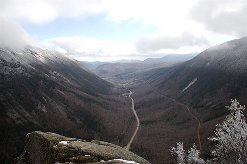
The photo above is from two of our guests who snowshoed up Mount Willard after I had suggested it to them during breakfast. They were definitely happy to have been able to see the beautiful panoramic views especially looking south straight down the Valley towards the towns of Bartlett, Glen, and North Conway.


What’s in the Mount Willard Area: 
Crawford Notch, one of the best examples of a glacially carved U-shaped valley anywhere in the world
•Evidence of rock slides on Mount Webster and Mount Willey
Peregrine falcons occasionally nest in the area


The trailhead for Mount Willard is located at the Gateway of Crawford Notch behind the Crawford Depot Information Center off US 302.

•From the Jackson-North Conway area, follow US 302 west at Glen where it splits from NH 16. US 302 passes through Bartlett, then heads north through Crawford Notch. At the top of the Notch, roughly 20 miles from the junction of NH 16 and US 302, the road goes through a narrow pass between two cliffs. The parking area for Crawford Depot, is a few hundred yards up the road on the left.

•From Twin Mountain, take US 302 east. Crawford Depot is on the right just beyond the turnoff for the AMC’s Highland Center, about eight miles south of the junction of US 302 and US 3.


Happy Trails!


Friday, February 11, 2011

Snowshoeing the Buttonwood Inn Trails

We strapped on our snowshoes yesterday and took the dogs on a hike heading out the back yard to the Buttonwood Trail.  To access it, we walked past the pool house through the neighbor's field to the point where you can either proceed on the Buttonwood Trail or hike the Mt. Surprise Trail.  We chose the Buttonwood Trail following the already trodden path by other snowshoers. 
This trail goes halfway up Bartlett Mountain and we snowshoed from East to West on a path that is just below the rock outcroppings.  We passed over several small streams through woods and partially open fields.  I was reminded that humans were not the only visitors wandering around these woods, as I noticed coyote, deer, turkey, and fox tracks near the trail. 

Just below the rock outcropping on Bartlett, the view opens up to reveal the Moat Mountains and Loon Mountain further west near Lincoln.  Just past this scenic lookout point, we snowshoed a little further and decided to head back down on the loop, rather than proceeding up the steep part of the trail which goes up to the Barlett Ledges.  The view from the Bartlett Ledges is phenomenal because you can see the Moats, North Conway Village, Cathedral Ledge, and off to the Northwest, the Presidentials in all their glory.

We proceeded down the trail and had glimpses of the Moats.  We crossed over a few more small, frozen streams before we connected to the Mt. Surprise Trail, which led us back to the field where we started our snowshoeing hike.  From the Mt. Surprise Trail, you can also hike up Nan's Loop (which is the summit of Mt. Surprise at 900 ft.) to view the Moats.

You too can enjoy these trails.  Just bring your snowshoes or rent them from Ragged Mountain Equipment in Glen for a day.  It's just you and the beautiful, peaceful forest and mountains.  Reserve on-line or call us at 1-800-258-2625!

Saturday, August 22, 2009

Hiking the Presidentials from The Buttonwood Inn

Just minutes from the Buttonwood Inn on Mopunt Surprise is The Presidential Range a mountain range located in the White Mountains of the state of New Hampshire, almost entirely in Coos County. The most notable summits of the range are named for prominent Americans, either public figures of the 18th and 19th centuries or Presidents.


The summits marked with an asterisk (*) are included on the peak-bagging list of 4,000-foot and higher mountains in New Hampshire; the others are excluded, in some cases because of lesser height and in others because of more technical criteria.


Aside from the notable summits, the geological Presidential Range contains a number of additional named peaks. Several of these peaks, drained on their west faces by the Dry River, are less accessible than the main and most visited ridge of the range and are therefore likely to be neglected, or mentioned as an afterthought, in discussing the range as whole.
Subsidiary peaks of Mount Washington: Ball Crag (6,106 ft); Nelson Crag (5,620 ft); Boott Spur (5,500 ft)


The Presidentials separate drainage via the Saco and Androscoggin Rivers into the Atlantic Ocean on the coast of Maine, from drainage into the Israel and Ammonoosuc Rivers, then into the Connecticut River, and then into Long Island Sound.


Thursday, August 6, 2009

Hike up Mt. Willard


Yesterday morning, Bill and I quickly finished our innkeeping duties and escaped up North on Route 302 to the trail head of Mt. Willard located behind the train station in Pinkham Notch. Though the rain clouds loomed overhead, we figured that equipped with our rain jackets and hats, we were covered for a cool summer rain. However, it only lasted a few minutes and we proceeded up Mt. Willard which is 2,804 feet to the cliffs overlooking the valley, Route 302, the scenic railroad tracks, Mt. Willey, and other mountains in the Presidentials.
http://www.outdoors.org/recreation/tripplanner/ideas/mt-willard.cfm

It's a well worn trail of moderate degree and maintained by the Park Service. In fact, on the way down, we passed the rangers fixing the trail. The trail starts out flat passing over a stream and then begins the incline up the mountain. About two-thirds of the way up, we passed by a waterfall that pours into Centennial Pool. We proceeded at a moderate pace and reached the cliffs after 1 hour and 15 minutes (about 1.5 miles). As mentioned, the view was spectacular and hauntingly beautiful with the clouds looming over the tops of the mountains, but it wasn't raining. In fact, it's a popular trail and there were around 20 people up there admiring the view and listening to the wildlife in the forest below. Hiking the mountain trails in the Whites renews our spirits and reminds of the astounding beauty and wildlife around us.